
A recent international study highlights the devastating impact of climate change on the Himalayas, revealing the intricate causes of the October 2023 flood in Sikkim, India. Scientists call for urgent early warning systems and stronger climate adaptation measures.
An international research team has released a new study on the catastrophic flood that devastated the Teesta River valley in Sikkim, India, in October 2023. The study, involving scientists from nine countries, including the University of Zurich (UZH), offers a comprehensive analysis of the event’s complex causes and far-reaching impacts, underscoring the urgency of addressing climate-related risks in high mountain regions.
On Oct. 3, 2023, a massive landslide comprising approximately 14.7 million cubic meters of frozen moraine material collapsed into South Lhonak Lake.
The landslide triggered a tsunami-like wave, towering up to 20 meters high, leading to a catastrophic glacial lake outburst flood (GLOF). The flood unleashed around 50 million cubic meters of water — enough to fill 20,000 Olympic-sized swimming pools — down the 385-kilometer-long Teesta River valley, causing widespread destruction.
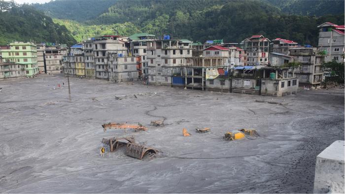
Caption: Flooding and destruction of Rangpo, over 130 km downstream of South Lhonak Lake
Credit: Praful Rao
“The thawing of permafrost and the instability of rock, ice and moraine structures pose major risks,” co-author Christian Huggel, the head of the Environment and Climate research group at UZH, said in a news release.
This sentiment reflects the dire condition of high-altitude regions and their increasing vulnerability due to climate change.
The deadly flood claimed at least 55 lives, with 70 people still missing. Infrastructure, including five hydroelectric power plants, was severely damaged or destroyed, leading to significant economic consequences for local communities. Massive erosion and sedimentation further exacerbated the disaster’s impact on agriculture and local businesses.
A key aspect of the study was the use of high-resolution remote sensing data to unravel the event’s dynamics.
“The use of high-resolution remote sensing data was crucial to understanding the complex processes and cascading effects of the flood in detail,” first author Ashim Sattar, a former postdoctoral researcher at UZH and now an assistant professor at the Indian Institute of Technology in Bhubaneswar, said in the news release.
The combination of satellite images, digital elevation models, numerical simulations and seismic data allowed the team to reconstruct the disaster with unprecedented detail.
The study highlighted the urgent need for effective early warning systems and international cooperation to tackle such hazards.
“Our findings highlight the urgent need for early warning systems and international cooperation to address such challenges,” added Sattar.
Moreover, the research underscored the importance of preemptive measures, revealing that the moraines’ instability had been apparent for years, with shifts of up to 15 meters per year. This calls for coordinated monitoring and preventive strategies to mitigate future disasters.
As climate change continues to accelerate, the frequency of such multihazard cascades is likely to rise.
“The case of South Lhonak Lake is a reminder to take climate risks in mountain regions worldwide more seriously,” added Huggel.
Sattar stressed, “We need better risk modeling and assessment, as well as robust adaptation strategies, to minimize future disasters.”
The study’s insights are crucial for improving preparedness and response strategies, advocating for stronger regulation of hydropower development in high-risk areas, enhanced monitoring of glacial lakes and the implementation of early warning systems.
Published in the journal Science, the study serves as a clarion call for enhanced climate action to protect vulnerable mountain communities from the escalating threats of climate change.